Name a Creek, Cove, or Place on lake Cumberland.

Any random thought and item for the Lake

Moderators: E_, LC addict, FasterThanYou, crwky

Post Reply
User avatar
E_
Site Admin
Posts: 14802
Joined: Fri Oct 24, 2008 10:26 pm
Marina/Ramp: Currently mostly out of Jamestown but spend a lot of time at the other Marinas.

Pre2012-Conley Bottom Mostly, Waitsboro, Alligator I&II ramps, Leesford, Pulaski County Park (when it has water), Grider, State Dock (via boat), and Jamestown are a few places you might find me.
Location: Kentucky (Lake Cumberland)
Contact:

Key Spots on the Lake Pics

Post by E_ »

Got great pic of a Marina or a well known spot on the lake? Share it here along with a description and maybe even a GPS coordinate if you wish.

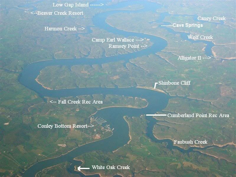
I will start with Beaver Creek and the Marina.. 36.861168,-84.978789
Beaver Creek Marina .JPG
Beaver Creek Marina .JPG (82.55 KiB) Viewed 38244 times
The shots are a little Blurry and hazy from the morning fog staying around too long but that just welcomes you to post better ones. :p
Attachments
Beaver Creek Marina 2007.JPG
Beaver Creek Marina 2007.JPG (83 KiB) Viewed 38246 times
Beaver DSCN1654.JPG
Beaver DSCN1654.JPG (76.23 KiB) Viewed 38246 times
Beaver DSCN1656.JPG
Beaver DSCN1656.JPG (102.28 KiB) Viewed 38246 times
Beaver DSCN1657.JPG
Beaver DSCN1657.JPG (48.72 KiB) Viewed 38246 times
bEAVER DSCN1662.JPG
bEAVER DSCN1662.JPG (58.99 KiB) Viewed 38249 times
bEAVERDSCN1660.JPG
bEAVERDSCN1660.JPG (52.15 KiB) Viewed 38246 times
BeaverDSCN1661.JPG
BeaverDSCN1661.JPG (56.18 KiB) Viewed 38246 times
Buy American, the job you save just might be your own.
User avatar
KYCanuck
Better Member
Posts: 441
Joined: Wed Oct 29, 2008 2:53 pm
Marina/Ramp: Burnside Marina - Yearly slip
Location: NKY - Woodson Bend - Somewhere on the lake

Re: Key Spots on the Lake Pics

Post by KYCanuck »

Ah, those hot summer days, I miss them already!
Brrrrr!

The Red Pontiac G8 GT in my Avatar is for Sale - Ask me about it!
User avatar
E_
Site Admin
Posts: 14802
Joined: Fri Oct 24, 2008 10:26 pm
Marina/Ramp: Currently mostly out of Jamestown but spend a lot of time at the other Marinas.

Pre2012-Conley Bottom Mostly, Waitsboro, Alligator I&II ramps, Leesford, Pulaski County Park (when it has water), Grider, State Dock (via boat), and Jamestown are a few places you might find me.
Location: Kentucky (Lake Cumberland)
Contact:

Name a Creek, Cove, or Place on lake Cumberland.

Post by E_ »

Name a Creek, Cove, or Place on lake Cumberland.

Just name one per post and don't repeat any. If you have GPS coordinates and directions to include that (we might just be calling some of the same places different names). Also if you have a good represenative pic post that.


Here is a beginning pic, feel free to use one of the locations in it if they are not posted by someone else already.
DSCN0132Labeled18.png
DSCN0132Labeled18.png (1.04 MiB) Viewed 15093 times
Image
Sorry if not showing up Photobucket has gotten greedy.
Image

I'll start:
Attachments
070402_35k_labelaerial.jpg
070402_35k_labelaerial.jpg (21.99 KiB) Viewed 15093 times
DSCN0132Labeled.jpg
DSCN0132Labeled.jpg (72.36 KiB) Viewed 15093 times
Buy American, the job you save just might be your own.
User avatar
E_
Site Admin
Posts: 14802
Joined: Fri Oct 24, 2008 10:26 pm
Marina/Ramp: Currently mostly out of Jamestown but spend a lot of time at the other Marinas.

Pre2012-Conley Bottom Mostly, Waitsboro, Alligator I&II ramps, Leesford, Pulaski County Park (when it has water), Grider, State Dock (via boat), and Jamestown are a few places you might find me.
Location: Kentucky (Lake Cumberland)
Contact:

Re: Name a Creek, Cove, or Place on lake Cumberland.

Post by E_ »

Shinbone Cliff
36.971093,-84.868297 to 36.95772,-84.871215

Or Between Points A and B at this link
http://maps.yahoo.com/#mvt=h&lat=36.985 ... -84.871215

Straight across from the Cumberland Point Ramp yet on the same "north" shore of the Lake.
Shinbone Cliff.JPG
Shinbone Cliff.JPG (34.81 KiB) Viewed 39004 times
Shinbone Cliff pic.JPG
Shinbone Cliff pic.JPG (202.24 KiB) Viewed 39003 times
Shinbone Cliff pic2.JPG
Shinbone Cliff pic2.JPG (129.6 KiB) Viewed 39002 times
Shinbone 2009.jpg
Shinbone 2009.jpg (76.48 KiB) Viewed 38799 times

Updated 7-20-2017
https://www.google.com/maps/place/Shinb ... 84.8699474

https://books.google.com/books?id=fj3Kc ... er&f=false
Shinbone Google docs.png
Shinbone Google docs.png (568.59 KiB) Viewed 18804 times
https://books.google.com/books?id=mnFiZ ... er&f=false


This reference to Shinbone was in the 1920s
https://books.google.com/books?id=mnFiZ ... er&f=false
Shinbone Cliff 1922.png
Shinbone Cliff 1922.png (280.34 KiB) Viewed 18804 times
https://mapcarta.com/20962096

https://books.google.com/books?id=wKEXG ... er&f=false
Buy American, the job you save just might be your own.
User avatar
FasterThanYou
MASTER MEMBER
Posts: 2068
Joined: Sat Oct 25, 2008 4:22 pm
Marina/Ramp: Woodson Bend
Location: Lake Cumberland
Contact:

Re: Name a Creek, Cove, or Place on lake Cumberland.

Post by FasterThanYou »

Wally's dock - on the South Fork. :D
Image

Keyboards should be equipped with breathalyzers
User avatar
E_
Site Admin
Posts: 14802
Joined: Fri Oct 24, 2008 10:26 pm
Marina/Ramp: Currently mostly out of Jamestown but spend a lot of time at the other Marinas.

Pre2012-Conley Bottom Mostly, Waitsboro, Alligator I&II ramps, Leesford, Pulaski County Park (when it has water), Grider, State Dock (via boat), and Jamestown are a few places you might find me.
Location: Kentucky (Lake Cumberland)
Contact:

Re: Name a Creek, Cove, or Place on lake Cumberland.

Post by E_ »

Got a pic Faster?

LOL, I just noticed this thread is very similar to
viewtopic.php?f=34&t=94
But the link will not work as I merged the threads 5-24-2011

Oh well jump in guys and share the knowledge / fun.
Buy American, the job you save just might be your own.
User avatar
FasterThanYou
MASTER MEMBER
Posts: 2068
Joined: Sat Oct 25, 2008 4:22 pm
Marina/Ramp: Woodson Bend
Location: Lake Cumberland
Contact:

Re: Name a Creek, Cove, or Place on lake Cumberland.

Post by FasterThanYou »

Wally's dock - just down river from the Villas of Woodson Bend's dock.
Image
Attachments
Wally01.jpg
Wally01.jpg (81.83 KiB) Viewed 11861 times
Image

Keyboards should be equipped with breathalyzers
User avatar
E_
Site Admin
Posts: 14802
Joined: Fri Oct 24, 2008 10:26 pm
Marina/Ramp: Currently mostly out of Jamestown but spend a lot of time at the other Marinas.

Pre2012-Conley Bottom Mostly, Waitsboro, Alligator I&II ramps, Leesford, Pulaski County Park (when it has water), Grider, State Dock (via boat), and Jamestown are a few places you might find me.
Location: Kentucky (Lake Cumberland)
Contact:

CAMP EARL WALLACE

Post by E_ »

Camp Earl Wallace

Here is where the Poker Run Checkpoint normally sets up:
http://maps.yahoo.com/#mvt=h&lat=36.946 ... 18&zoom=17

This is the actual Camp Earl Wallace Spot
http://maps.yahoo.com/#mvt=h&lat=36.943 ... 87&zoom=17

Camp Earl Wallace.JPG
Camp Earl Wallace.JPG (92.44 KiB) Viewed 38734 times
Camp Earl Wallace Zoomed out.JPG
Camp Earl Wallace Zoomed out.JPG (133.41 KiB) Viewed 38734 times
2007 Poker Run Resize1.jpg
2007 Poker Run Resize1.jpg (66.47 KiB) Viewed 34459 times
2007 Poker Run Resize2.jpg
2007 Poker Run Resize2.jpg (68.17 KiB) Viewed 34459 times
Two Boats Beach Wrecked at Camp Earl Wallace Poker Run 2007
2007 Poker Run Resize3.jpg (67.44 KiB) Viewed 34459 times
Buy American, the job you save just might be your own.
User avatar
E_
Site Admin
Posts: 14802
Joined: Fri Oct 24, 2008 10:26 pm
Marina/Ramp: Currently mostly out of Jamestown but spend a lot of time at the other Marinas.

Pre2012-Conley Bottom Mostly, Waitsboro, Alligator I&II ramps, Leesford, Pulaski County Park (when it has water), Grider, State Dock (via boat), and Jamestown are a few places you might find me.
Location: Kentucky (Lake Cumberland)
Contact:

CLIFTY CREEK

Post by E_ »

There are two Clifty Creeks. One is near State Dock on the west end and is not known very well. The one most speak of is on the east end.

That Clifty most are asking about is the one near Leesford. It is the more calm east end Party Cove. If heading north on Fishing Creek it is the next cove after Needle point on your left.

If heading South it is the first BIG cove on your right after leaving Leesford Marina.

GPS - 37.023774,-84.7065 If you want to see it go to http://maps.yahoo.com/#mvt=h&lat=37.023 ... 71&zoom=14 You have have to turn the hybrid mode on and zoom down to the destination.

I know Ohio Navy.com has posted some pics of Clifty Creek on here and their site http://www.OhioNavy.com

http://www.ohionavy.com/sys-tmpl/lakecu ... _all.nhtml

Here is one of his pics from the site.
Image
Buy American, the job you save just might be your own.
User avatar
E_
Site Admin
Posts: 14802
Joined: Fri Oct 24, 2008 10:26 pm
Marina/Ramp: Currently mostly out of Jamestown but spend a lot of time at the other Marinas.

Pre2012-Conley Bottom Mostly, Waitsboro, Alligator I&II ramps, Leesford, Pulaski County Park (when it has water), Grider, State Dock (via boat), and Jamestown are a few places you might find me.
Location: Kentucky (Lake Cumberland)
Contact:

Re: Name a Creek, Cove, or Place on lake Cumberland.

Post by E_ »

Can one of you guys do a similar post for Cemetary Isle and give GPS and maybe a pic or two? I am not totally sure where it is... Also someone here: http://www.facebook.com/home.php#/event ... 446&ref=ts would like to know as well.

Thanks

E


PS
The way I get the GPS is I pull up the Hybrid mode of Maps.yahoo.com and then I zoom in on the spot I want. I then right click the spot and say drive to here and it will fill in the blanks on the side with the GPS coordinates.
For example here is where the skull on shinbone should be
http://maps.yahoo.com/#mvt=h&lat=36.968 ... 78&zoom=17
Buy American, the job you save just might be your own.
User avatar
E_
Site Admin
Posts: 14802
Joined: Fri Oct 24, 2008 10:26 pm
Marina/Ramp: Currently mostly out of Jamestown but spend a lot of time at the other Marinas.

Pre2012-Conley Bottom Mostly, Waitsboro, Alligator I&II ramps, Leesford, Pulaski County Park (when it has water), Grider, State Dock (via boat), and Jamestown are a few places you might find me.
Location: Kentucky (Lake Cumberland)
Contact:

Power Plant east of Burnside

Post by E_ »

The PowerPlant East of Burnside
36.997918,-84.592137

http://maps.yahoo.com/#mvt=h&lat=36.996 ... 65&zoom=17
Attachments
0815081729resized.jpg
0815081729resized.jpg (52.67 KiB) Viewed 34459 times
Buy American, the job you save just might be your own.
watt money
Better Member
Posts: 280
Joined: Tue Oct 13, 2009 6:47 pm
Marina/Ramp: Conley Bottom

Re: Name a Creek, Cove, or Place on lake Cumberland.

Post by watt money »

Used to hang out at Thomas Branch a lot before I bought my cruiser, don't venture to far from Conley much anymore.
Attachments
t.JPG
t.JPG (78.98 KiB) Viewed 38694 times
User avatar
LC addict
MASTER MEMBER
Posts: 1049
Joined: Sat Oct 25, 2008 7:56 pm
Marina/Ramp: JRM
Contact:

Re: Name a Creek, Cove, or Place on lake Cumberland.

Post by LC addict »

FasterThanYou wrote:Wally's dock - just down river from the Villas of Woodson Bend's dock.
Image

I don't know where this is, but I am thinking of checking it out and seeing if Mr. Snicker's wants to go for a boat ride with me (When SFW's not looking). He's one of the cutest dogs I've ever seen! Loved his little leather jacket last wknd!
My greatest accomplishments call me Mom!
User avatar
E_
Site Admin
Posts: 14802
Joined: Fri Oct 24, 2008 10:26 pm
Marina/Ramp: Currently mostly out of Jamestown but spend a lot of time at the other Marinas.

Pre2012-Conley Bottom Mostly, Waitsboro, Alligator I&II ramps, Leesford, Pulaski County Park (when it has water), Grider, State Dock (via boat), and Jamestown are a few places you might find me.
Location: Kentucky (Lake Cumberland)
Contact:

Re: Name a Creek, Cove, or Place on lake Cumberland.

Post by E_ »

PS I have updated the large lakecumberland map from 2006 with easier to read labels and added a couple more points of interest. ;)
VERY LARGE FILE!
You may want to right click and save as.
http://www.lakecumberlandboaters.com/fi ... 4-2011.bmp

When yo do view it make sure you look at it at 100% zoom some. It is pretty interesting to view all the little areas the county road maps it was created from show.

Here is a thread on LakeCumberland.com that goes into more detail
http://lakecumberland.com/forum/viewthr ... #pid370810
Buy American, the job you save just might be your own.
User avatar
E_
Site Admin
Posts: 14802
Joined: Fri Oct 24, 2008 10:26 pm
Marina/Ramp: Currently mostly out of Jamestown but spend a lot of time at the other Marinas.

Pre2012-Conley Bottom Mostly, Waitsboro, Alligator I&II ramps, Leesford, Pulaski County Park (when it has water), Grider, State Dock (via boat), and Jamestown are a few places you might find me.
Location: Kentucky (Lake Cumberland)
Contact:

Re: Name a Creek, Cove, or Place on lake Cumberland.

Post by E_ »

Map updated again today
http://www.lakecumberlandboaters.com/fi ... 6-2011.bmp

Yes the date in the name is a day ahead of itself.

I would love to see some people post pictures and places like in the first posts on this thread if when they have time.
Buy American, the job you save just might be your own.
User avatar
E_
Site Admin
Posts: 14802
Joined: Fri Oct 24, 2008 10:26 pm
Marina/Ramp: Currently mostly out of Jamestown but spend a lot of time at the other Marinas.

Pre2012-Conley Bottom Mostly, Waitsboro, Alligator I&II ramps, Leesford, Pulaski County Park (when it has water), Grider, State Dock (via boat), and Jamestown are a few places you might find me.
Location: Kentucky (Lake Cumberland)
Contact:

Re: Name a Creek, Cove, or Place on lake Cumberland.

Post by E_ »

TTT, come on and post a spot with a pic
Buy American, the job you save just might be your own.
User avatar
E_
Site Admin
Posts: 14802
Joined: Fri Oct 24, 2008 10:26 pm
Marina/Ramp: Currently mostly out of Jamestown but spend a lot of time at the other Marinas.

Pre2012-Conley Bottom Mostly, Waitsboro, Alligator I&II ramps, Leesford, Pulaski County Park (when it has water), Grider, State Dock (via boat), and Jamestown are a few places you might find me.
Location: Kentucky (Lake Cumberland)
Contact:

Sid Bell aka Sid Belle aka Sidbell aka Family aka Little Fal

Post by E_ »

I thought this one was already in this thread but I guess not. (come on guys join in and add some spots with GPS links and pics if possible.

Sid Bell Falls aka Sid Belle Falls aka Sidbell Falls aka Family Falls aka Little Falls
36.807137, -85.026616


Zoom to point "A" on this map http://maps.google.com/maps?saddr=36.80 ... sz=17&z=11

or go to 36.807137, -85.026616 from any map system.

Here is a 2011 Photo LCAddict posted (CLICK HERE)
Sid Belle Falls LC Addict's Photo from June 2011.JPG
Sid Belle Falls LC Addict's Photo from June 2011.JPG (52.2 KiB) Viewed 35219 times
Here is a 2002 one MPII posted CLICK HERE
Sid Belle Falls MPII's Photo from 2002.JPG
Sid Belle Falls MPII's Photo from 2002.JPG (41.88 KiB) Viewed 35219 times
See also http://lakecumberland.com/forum/viewthr ... ?tid=35853 for another photo

A couple photos E took in April 2012
Not very deep, got to 3' and turned around
IMG_20120422_150716 (Medium).jpg
IMG_20120422_150716 (Medium).jpg (54.03 KiB) Viewed 35219 times
See also viewtopic.php?f=34&t=5538
IMG_20120422_151007-1 (Medium).jpg
IMG_20120422_151007-1 (Medium).jpg (110.74 KiB) Viewed 35219 times
Video here download/file.php?id=2846


Quote added from a Lake Cumberland Boaters.com facebook post on July 16 - 2015
Donald Forsythe

4 mins · Lebanon, TN
.

Earlier this month I posted: Sid Bell Falls.
This waterfall has a lot of names. None of them are official. I think we should use just one name for this place to avoid confusion.

When I researched the first Lake Cumberland Boating Guide (1993) the COE ranger I was working with related the Bell family once had a small grist mill near this location. So the name Bell’s Mill Falls he used seemed to fit. I continue to use that name in The Lake Cumberland Boating Guide 2nd Edition. The cove identification number is HC-3 since it is at the rear of Handcock Creek.

Descendants of a Sid Bell kept the land in this area and I think they still own it. I am trying to contact a local historian or someone in the Bell family who hopefully will shed some light on this. I will post whatever I learn.

Here is the update:

Today I described this waterfall location to a Bell family member who was recommended to me as well versed in Bell family history. The family member immediately responded, “yep, that is Sid Bell Falls. He was my Grandfather.” So, I will say grandfather to grandson verification trumps all else and is good enough for me. In any subsequent editions of The Lake Cumberland Boating Guide I will use the name Sid Bell Falls for the cove numbered as HC-3 in the guide.

Unless someone can put forward a compelling reason to do otherwise I wish to recommend for sake of consistency we stop using all the “aka” names that are floating around for this waterfall and stick with Sid Bell Falls. Among those, I think, are Sid Belle Falls, Handcock Falls and Family Falls.

Although I had the name of the Falls incorrect the family member said yes to the question of a grist mill once existing on the property.
BTW, Sid Bell died in 1948 therefore he was alive when the dam was under construction but he was not around to see what Lake Cumberland would become.
Buy American, the job you save just might be your own.
User avatar
E_
Site Admin
Posts: 14802
Joined: Fri Oct 24, 2008 10:26 pm
Marina/Ramp: Currently mostly out of Jamestown but spend a lot of time at the other Marinas.

Pre2012-Conley Bottom Mostly, Waitsboro, Alligator I&II ramps, Leesford, Pulaski County Park (when it has water), Grider, State Dock (via boat), and Jamestown are a few places you might find me.
Location: Kentucky (Lake Cumberland)
Contact:

Re: Name a Creek, Cove, or Place on lake Cumberland.

Post by E_ »

POP QUIZ!!!!

What is this spot? lol
Attachments
DSCF2732.JPG
DSCF2732.JPG (125.53 KiB) Viewed 34462 times
Buy American, the job you save just might be your own.
User avatar
E_
Site Admin
Posts: 14802
Joined: Fri Oct 24, 2008 10:26 pm
Marina/Ramp: Currently mostly out of Jamestown but spend a lot of time at the other Marinas.

Pre2012-Conley Bottom Mostly, Waitsboro, Alligator I&II ramps, Leesford, Pulaski County Park (when it has water), Grider, State Dock (via boat), and Jamestown are a few places you might find me.
Location: Kentucky (Lake Cumberland)
Contact:

Re: Name a Creek, Cove, or Place on lake Cumberland.

Post by E_ »

Ok, YOU GUYS SUCK on participation. I'm giving you all an F. lol


Here is a pic I created for LakeCumberland.com to help with a CLifty vs Clifty question. Figured I would put it in this thread too.
Clifty Clip Nifty Clifty.JPG
Clifty Clip Nifty Clifty.JPG (112.49 KiB) Viewed 34300 times

This goes with my post http://lakecumberlandboaters.com/forum/ ... 4460#p7995 above.
Buy American, the job you save just might be your own.
User avatar
Pop-O
Better Member
Posts: 285
Joined: Mon Jan 23, 2012 8:21 pm
Marina/Ramp: State Dock/Punkin Creek

Re: Name a Creek, Cove, or Place on lake Cumberland.

Post by Pop-O »

E_HILLMAN wrote:POP QUIZ!!!!

What is this spot? lol
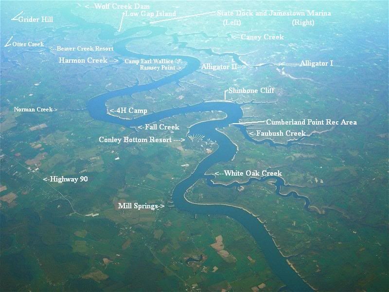
Looks like the area where Cave Springs-Wolf Creek Marina would be situated now.
I have taken the road least traveled................and now I am freakin LOST !
User avatar
E_
Site Admin
Posts: 14802
Joined: Fri Oct 24, 2008 10:26 pm
Marina/Ramp: Currently mostly out of Jamestown but spend a lot of time at the other Marinas.

Pre2012-Conley Bottom Mostly, Waitsboro, Alligator I&II ramps, Leesford, Pulaski County Park (when it has water), Grider, State Dock (via boat), and Jamestown are a few places you might find me.
Location: Kentucky (Lake Cumberland)
Contact:

Re: Name a Creek, Cove, or Place on lake Cumberland.

Post by E_ »

Yep! You got it Pop-O! :)

It was the first year the lake went down. (might have) drove out onto the "Island" with my truck and took that photo. Guess next year it will be all under water up to the vegetation line in the photo...
Buy American, the job you save just might be your own.
User avatar
E_
Site Admin
Posts: 14802
Joined: Fri Oct 24, 2008 10:26 pm
Marina/Ramp: Currently mostly out of Jamestown but spend a lot of time at the other Marinas.

Pre2012-Conley Bottom Mostly, Waitsboro, Alligator I&II ramps, Leesford, Pulaski County Park (when it has water), Grider, State Dock (via boat), and Jamestown are a few places you might find me.
Location: Kentucky (Lake Cumberland)
Contact:

Re: Name a Creek, Cove, or Place on lake Cumberland.

Post by E_ »

Updated the LakeCumberland Map
Updated Cave Springs to Wolf Creek and made the Beaver Creek dot red, as well as I overlaid another color over Wayne county so you could differentiate it from Pulaski.

BMP 48.8MB
http://www.lakecumberlandboaters.com/fi ... 3-2014.bmp

PNG - 20.2 MB
http://www.lakecumberlandboaters.com/fi ... 3-2014.PNG

Let me know if you have any other changes etc. and one year I'll get around to it. lol :D

Preview below
Attachments
Preview.JPG
Preview.JPG (63.82 KiB) Viewed 33859 times
Buy American, the job you save just might be your own.
User avatar
E_
Site Admin
Posts: 14802
Joined: Fri Oct 24, 2008 10:26 pm
Marina/Ramp: Currently mostly out of Jamestown but spend a lot of time at the other Marinas.

Pre2012-Conley Bottom Mostly, Waitsboro, Alligator I&II ramps, Leesford, Pulaski County Park (when it has water), Grider, State Dock (via boat), and Jamestown are a few places you might find me.
Location: Kentucky (Lake Cumberland)
Contact:

Re: Name a Creek, Cove, or Place on lake Cumberland.

Post by E_ »

Ttt, Lake is up and no one has posted about 76 or the party cove up South Fork
Buy American, the job you save just might be your own.
User avatar
E_
Site Admin
Posts: 14802
Joined: Fri Oct 24, 2008 10:26 pm
Marina/Ramp: Currently mostly out of Jamestown but spend a lot of time at the other Marinas.

Pre2012-Conley Bottom Mostly, Waitsboro, Alligator I&II ramps, Leesford, Pulaski County Park (when it has water), Grider, State Dock (via boat), and Jamestown are a few places you might find me.
Location: Kentucky (Lake Cumberland)
Contact:

Re: Name a Creek, Cove, or Place on lake Cumberland. 76 FAL

Post by E_ »

Good Gosh you guys , I'll do another for you

Since the water is up, here is 76 Falls. 36.779351, -85.126022

...from the Dam headed east first big creek on your right (Main Indian Creek), go on past Grider Hill, then continue on to the last right turn up the creek (Williams Creek), take that creek to the second right turn (Indian Creek).

See pic below
76.JPG
76.JPG (78.69 KiB) Viewed 33546 times

Click here for google map
https://www.google.com/maps/dir/36.7794 ... m2!1m0!1m0
Pay no attention to lake levels in google maps if the image is 2013 or older. ;)
76 Falls.PNG
76 Falls.PNG (1.24 MiB) Viewed 33546 times
IMG_20140517_141554514.jpg
IMG_20140517_141554514.jpg (110.78 KiB) Viewed 33546 times
76.JPG
76.JPG (23.26 KiB) Viewed 33541 times
https://www.youtube.com/watch?feature=p ... c6ojekGymo


See Also http://lakecumberlandboaters.com/forum/ ... 36&p=46625
Buy American, the job you save just might be your own.
SEARAYDOUG
I posted something! WooHoo!
Posts: 2
Joined: Tue Jul 19, 2011 11:29 am

Re: Name a Creek, Cove, or Place on lake Cumberland.

Post by SEARAYDOUG »

Party Cove, South Fork south 8 miles from Burnside Marine by Burnside Island and Woodsend bend on your right.
Party Cove Cliff.JPG
Party Cove Cliff.JPG (82.27 KiB) Viewed 33146 times
User avatar
E_
Site Admin
Posts: 14802
Joined: Fri Oct 24, 2008 10:26 pm
Marina/Ramp: Currently mostly out of Jamestown but spend a lot of time at the other Marinas.

Pre2012-Conley Bottom Mostly, Waitsboro, Alligator I&II ramps, Leesford, Pulaski County Park (when it has water), Grider, State Dock (via boat), and Jamestown are a few places you might find me.
Location: Kentucky (Lake Cumberland)
Contact:

Re: Name a Creek, Cove, or Place on lake Cumberland.

Post by E_ »

Thanks SeaRay Doug! I think this might be the proper coordinates to go with your info and photo..
https://www.google.com/maps/place/36%C2 ... !1s0x0:0x0


36°56'26.1"N 84°37'12.7"W

36.940586, -84.620197
Buy American, the job you save just might be your own.
JLA
SUPER Member
Posts: 586
Joined: Wed Oct 29, 2008 9:09 pm

Re: Name a Creek, Cove, or Place on lake Cumberland.

Post by JLA »

Finally, Burnside & Woodson Bend gettin' some love.
Some days I'm the baby, some days I'm the diaper........
User avatar
E_
Site Admin
Posts: 14802
Joined: Fri Oct 24, 2008 10:26 pm
Marina/Ramp: Currently mostly out of Jamestown but spend a lot of time at the other Marinas.

Pre2012-Conley Bottom Mostly, Waitsboro, Alligator I&II ramps, Leesford, Pulaski County Park (when it has water), Grider, State Dock (via boat), and Jamestown are a few places you might find me.
Location: Kentucky (Lake Cumberland)
Contact:

Re: Name a Creek, Cove, or Place on lake Cumberland.

Post by E_ »

We need more listed on here...
Buy American, the job you save just might be your own.
User avatar
E_
Site Admin
Posts: 14802
Joined: Fri Oct 24, 2008 10:26 pm
Marina/Ramp: Currently mostly out of Jamestown but spend a lot of time at the other Marinas.

Pre2012-Conley Bottom Mostly, Waitsboro, Alligator I&II ramps, Leesford, Pulaski County Park (when it has water), Grider, State Dock (via boat), and Jamestown are a few places you might find me.
Location: Kentucky (Lake Cumberland)
Contact:

Re: Name a Creek, Cove, or Place on lake Cumberland.

Post by E_ »

Cool Waterfall submitted on our FB page by Shannon Savage Schmitz
https://www.facebook.com/photo.php?fbid ... =3&theater
Shannon Savage Schmitz waterfall pic.jpg
Shannon Savage Schmitz waterfall pic.jpg (162.07 KiB) Viewed 27538 times
Attachments
Shannon SS waterfall Location.jpg
Shannon SS waterfall Location.jpg (24.43 KiB) Viewed 27538 times
Buy American, the job you save just might be your own.
User avatar
E_
Site Admin
Posts: 14802
Joined: Fri Oct 24, 2008 10:26 pm
Marina/Ramp: Currently mostly out of Jamestown but spend a lot of time at the other Marinas.

Pre2012-Conley Bottom Mostly, Waitsboro, Alligator I&II ramps, Leesford, Pulaski County Park (when it has water), Grider, State Dock (via boat), and Jamestown are a few places you might find me.
Location: Kentucky (Lake Cumberland)
Contact:

Large Cascade Waterfall in Beaver Creek

Post by E_ »

Large Cascade Waterfall in Beaver Creek
Screenshot_20170528-224938.jpg
Screenshot_20170528-224938.jpg (1.85 MiB) Viewed 22811 times
Attachments
FB_IMG_1496026154738.jpg
FB_IMG_1496026154738.jpg (37.86 KiB) Viewed 22811 times
Buy American, the job you save just might be your own.
User avatar
E_
Site Admin
Posts: 14802
Joined: Fri Oct 24, 2008 10:26 pm
Marina/Ramp: Currently mostly out of Jamestown but spend a lot of time at the other Marinas.

Pre2012-Conley Bottom Mostly, Waitsboro, Alligator I&II ramps, Leesford, Pulaski County Park (when it has water), Grider, State Dock (via boat), and Jamestown are a few places you might find me.
Location: Kentucky (Lake Cumberland)
Contact:

The Waterfall Trail by Janette Keller Marson and others??

Post by E_ »

http://lakecumberlandvacation.com/lake- ... all-trail/

Lake Cumberland Waterfall Trail


Photo of girls sitting in front of a beautiful waterfall on Lake Cumberland


Lake Cumberland is famous as the Houseboating Capital and is one of America’s favorite lakes for boating, fishing, tubing or just cruising around. One thing that everyone agrees on is that Lake Cumberland is one of the most beautiful lakes in Kentucky – featuring gorgeous rocky cliffs, crystal clear water and of course… spectacular waterfalls!

Photo of someone on top of a Lake Cumberland waterfall

We have put together a small list of Lake Cumberland Waterfalls for you to find with your GPS… of course this is just a beginning, keep watching as our list continues to grow.

Many waterfalls are best seen after a heavy rain.

GREASY CREEK:

Two small Greasy Creek Waterfalls – N 36° 58.004′ W 085° 03.858′

Photo of a fairly large waterfall on Lake Cumberland

Greasy Creek Waterfall with Rope swing – N 36°58.072′ W 085°04.230′

Greasy Creek Waterfall (The Big One) – N 36°57.638′ W 85°04.713′ This lovely waterfall is 4 levels. A rope swing is in the waterfall area.

Greasy Creek on the way to old 127 Bridge – N 36°57.936 W085°04.834′ . This is a small waterfall on the way to the bridge. Be sure to go slow and stay on the rock wall side, which is the deepest part. Be sure to use a depth finder if you have one!

Woolen Mill Waterfalls – N 36° 57.938′ W 85° 04.972′ . There are two lovely waterfalls on the other side of the bridge. To be safe, only access this area by canoe, kayak or small watercraft – Check the water depth!

Harbor Springs/The Bluff Waterfall – N 36° 56.618′ W 085° 02.273′ . Two waterfalls can be found in this area.

LILY CREEK:

Lily Creek Smaller Waterfall – N 36° 57.736′ W 085° 02.324′ . This is a smaller waterfall before you get to the “Little Louisville” waterfall. This smaller waterfall is located across from a boat platform.

Little Louisville Waterfall – N 36° 57.800 W 085° 02.461′

INDIAN CREEK:

Photo of 76 Falls - the largest waterfall on Lake Cumberlnad

76 Falls – N 36° 46.807′ W 085° 07.551′ – 76 Falls is the largest waterfall on Lake Cumberland at 37′ tall at the lake elevation of 723′. *Think twice before jumping off the top of this waterfall (even if you see other people doing it). There have been fatalities and many neck and spinal injuries as a result of hitting the water from the top of the falls. Just don’t do it!

OTTER CREEK:

Sid Bell Falls – N 36° 48.460′ W 085° 01.636′ – Handcock Creek ends here in a 5′ waterfall. The banks near the waterfall are short ledges with trees close to the water. *Before Lake Cumberland was created, Bell’s Mill was located here.

BEAVER CREEK:

Photo of a Lake Cumberland Waterfall in the Beaver Creek Area

Twyford Point – N 36° 8304′ W 84° 9385′ – There is a lovely waterfall located in the Twyford Point area of Lake Cumberland – I believe these are the coordinates. Someone also recently used the address of 2171 Twyford Point Road, Monticello to reach the waterfall by water , which might be more accurate.

NORMAN HOLLOW:

Norman Hollow Waterfall – N 36°.9001030 W 84° .8845190
Waterfalls.png
Waterfalls.png (692.79 KiB) Viewed 18772 times
Buy American, the job you save just might be your own.
Post Reply

Return to “General Forum of Lake Cumberland”